ABS Consulting Group, Inc.: Home | Blog | Resume | Speaking | Publications
Showing posts with label weekly. Show all posts

Thursday, October 28, 2021

GIS Ed Weekly: Snopes, PBS and the Big Ten take on geography and GIS

A note from the editor

This will be the last issue of GIS Ed Weekly. You can find the full archive here on my Ignite Education blog.

I wish readers all the best in your geography/GIS education pursuits!

Resources for teaching and learning

WaPo: The geography of the Great Resignation: First-time data shows where Americans are quitting the most - "Kentucky, Idaho, South Dakota and Iowa reported the highest increases in the rates of workers who quit their jobs in August, according to a new glimpse of quit rates in the labor market released Friday."

Thursday, October 21, 2021

GIS Ed Weekly: Godiva settling geographical court case for $20M

On and off campus

TAMU: A new way to map with conservation data - "The Texas A&M Natural Resources Institute, a unit of Texas A&M AgriLife, is seeking to engage land managers, citizens and policymakers in visualizing natural resource conflicts and solutions through a new mapping application called TxMAP."

The GW Hatchet: Geography department unable to access data as officials upgrade file system - "Researchers in the geography department said they’ve been unable to access their research data for more than a month as officials have been working to transition the Columbian College of Arts and Sciences’ online file storage system to an updated platform."

Thursday, October 14, 2021

GIS Ed Weekly: Philosophy lecturer uses video game map in presentation; students freak out

Resources for teaching and learning

 Veterinary colleges and minority-serving
institutions 2021
JVMA News: Map connects veterinary colleges, minority-serving institutions - "In an effort to promote recruitment of, collaboration with, and increased access and opportunity for underrepresented students, the American Association of Veterinary Medical Colleges has created an interactive map featuring locations of veterinary colleges along with institutions of higher education that serve minority populations, announced the AAVMC’s Vet-Med Educator newsletter." I was unable to find a legend to explain the colored dots' meanings.

Smithsonian: This Interactive Map Lets Users Explore England’s Hidden Archaeological Landscape - A new online tool draws on more than 500,000 aerial photographs taken over the past 30 years.

Thursday, October 7, 2021

GIS Ed Weekly: Are maps for machines the future?

Resources for teaching and learning

How long mail will take to arrive from Chicago.
Washington Post: DeJoy’s USPS slowdown plan will delay the mail. What’s it mean for your Zip code? - The maps are interesting, but so is the impact these changes will have on the U.S. economy, among other topics.

NPR: The Vinland Map, thought to be the oldest map of America, is officially a fake -  Experts from Yale, "who analyzed the map for authenticity found throughout it the presence of a 'titanium compound' that was not used in ink until the 1920s, according to Yale News. Researchers also pointed to an inscription in Latin on the back of the map as evidence that someone intentionally tried to make the map look as genuine as possible."

Thursday, September 30, 2021

GIS Ed Weekly: Students explore old Bloomington, Worcester's buses and Victoria's housing crisis

On and off campus
My favorite map in Bloomington story: you navigate
the map via modern image, but see details from 
the Sanborn Fire Insurance Maps from 1907!

Indiana Student Daily: Early 1900s Bloomington shows historic city, shifting landscape in interactive map - An, IU project called Reconstructing Bloomington,  displays data on early 1900s Bloomington. IU visiting geography professor John Baeten and his team of 19 undergraduate students used historic data to depict Bloomington’s physical and social landscape in 1907. 

Mass Transit: Clark University student calls for revamp of WRTA bus system - "A Clark University [GIS] student believes better frequency and increased ridership could be the result of a bus system that focuses on serving major, multimodal 'transit corridors.'"

Thursday, September 23, 2021

GIS Ed Weekly: GIS tackles snakebites, Mexican American civil rights and Sudan's refugee crisis

Resources for teaching and learning

Entry for Micrurus spixii
in The WHO Snakebite
Information and Data platform.
WHO: Snakebite envenoming: an interactive data platform to support the 2030 targets - The app has search tools for type of snake, range and antivenom information and invites user generated content.

UTSA Libraries tour highlights local influence on Mexican American civil rights - "A new, interactive tour produced by the UTSA Libraries and Institute of Texan Cultures allows users to experience San Antonio’s significant role in the Mexican American civil rights movement on the same streets where history was made."

Thursday, September 16, 2021

GIS Ed Weekly: A new Hopkins dashboard maps COVID behaviors

Resources for teaching and learning 

A screenshot from The Geography
The Pitch: The Geography is both a video game and a ~vibe~ generator -  A new video game based on real world data ("geographic data from Svalbard, Norway rendered into low-poly landscapes") may help calm active minds. 

Johns Hopkins: Johns Hopkins Center for Communication Programs Launches Comprehensive Global COVID Behavior Dashboard - The new dashboard "captures knowledge, attitudes, and behaviors around vaccines, masking, and other mitigation measures from respondents in more than 100 countries." Via @URISA.

Thursday, September 9, 2021

GIS Ed Weekly: What defines an advanced GIS course?

Resources for teaching and learning

Today UK News: The geography of AI - "AI activity in the U.S. is highly concentrated in a short list of ‘superstar’ aggregations and early adopter hubs, often arrayed along the coasts"

Twitter: Carl Churchill notes: "You can extend the interactivity of #StoryMaps with live charts made with #d3 and @observablehq notebooks. Here is a chart sitting in a notebook, hosted in a #Github pages site and then embedded right into a Story Map."

Thursday, September 2, 2021

GIS Ed Weekly: When a student poster ends up on a UN website

Resources for teaching and learning

Earth Observatory: Satellite Observes Power Outages in New Orleans - "A team of scientists from NASA’s Goddard Space Flight Center and the Universities Space Research Association (USRA) has mapped the outages using satellite data. The images above show nighttime lights data acquired on August 9 and 31 by the Suomi NPP satellite. The base maps make use of data collected by the Landsat 8 satellite." Visit the site for the swipe map; very powerful.

The Guardian: Atlas of the Invisible: using data to map the climate crisis - "Graphics from a new book show causes and consequences that are hard to detect with the naked eye." The book is by UCL geographer James Cheshire and designer Oliver Uberti.

Thursday, August 26, 2021

GIS Ed Weekly: The Fed explores the geography of remote work

Resources for teaching and learning  

- Sakira Ventura, a 28 year old music teacher from Valencia created an interactive Google map that features more than 500 female composers from across the globe. 

NY Times: These Maps Tell the Story of Two Americas: One Parched; One Soaked - "This divide, a wetter East and a drier West, reflects a broader pattern observed in the United States in recent decades." 

Thursday, August 19, 2021

GIS Ed Weekly: GIS making communities better

Resources for teaching and learning

Science: ‘Mind blowing’: Grizzly bear DNA maps onto Indigenous language families - "A new analysis has found that the grizzlies here [in coastal British Columbia Canada] form three distinct genetic groups, and these groups align closely with the region’s three Indigenous language families." Via @sarahebourne.

Art News: How I Made This: Anton Thomas’s Pictorial Maps - A look at how the Melbourne-based cartographer makes pictorial maps.

Thursday, August 12, 2021

GIS Ed Weekly: Understanding Afghanistan, protecting surf spots

Resources for teaching and learning 

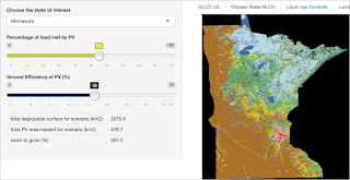
PV Magazine: Every state has room for solar to grow, researchers say - A map produced by researchers at the University of Albany offers a state-by-state analysis of energy needs and usable land for deployment.

CNN: One month later: These maps show how quickly Covid engulfed the US again - "More than 98% of US residents now live in an area where there is a 'high' or 'substantial' risk of Covid-19 community transmission, up from 19% of residents only a month ago."

Thursday, August 5, 2021

GIS Ed Weekly: Remote sensing illuminates floods, shipwrecks

Resources for teaching and learning

Insider: Map shows which states have the most support for Simone Biles after her withdrawal from Olympic all-around competition - "The team at betonline.ag set out to determine which US states support Biles following her unprecedented decision in Tokyo. Using geotagged Twitter data in the 48 hours following the team all-around competition — when Biles first bowed out — they tracked tweets, hashtags, and direct keyword phrases relating to Biles' choice to sit out." 

The Conversation: AI spots shipwrecks from the ocean surface – and even from the air - A doctoral student at UT writes: "I taught a computer how to recognize shipwrecks on the ocean floor from scans taken by aircraft and ships on the surface." Via @vWMaps. 

Thursday, July 29, 2021

GIS Ed Weekly: The Olympics teach us geography

Resources for teaching and learning 

A map depicting forest management history
 in the Bootleg Fire burn zone.
Oregon Public Radio: The Bootleg Fire grew fast. Did forest management play a role? - "The footprint of the Bootleg Fire includes a history of commercial logging, thinning, clear cutting, prescribed fire and other intensive management practices, according to Bryant Baker, conservation director of Santa Barbara, California, nonprofit Los Padres ForestWatch. Baker says those management activities contributed to the fire’s spread." And, he's got the maps to prove it. 

BBC: Stinky Bay? Local names added to map to aid coastal rescue - Ordnance Survey, the official national mapping agency of Great Britain will add local "nicknames" nationally with the goal of helping emergency response. "Ideally those in need of rescue should submit co-ordinates to make it easy for emergency services to locate them, but because not everyone has access to a device or a map, that is not always possible."

Thursday, July 22, 2021

GIS Ed Weekly: More Airbnbs in a neighborhood means more crime

Resources for teaching and learning

Business Insider: Striking map shows the vaccination divide between a few rich countries and the rest of the world - The map, from Max Roser of the site Our World in Data, shows the percentage of each country's population to receive at least one dose of a coronavirus vaccine.

Northeastern: When Airbnbs increase in a neighborhood, so does crime. Here’s why. - The relationship is likely because the highly transient housing “pokes holes in the social fabric of the neighborhood,” says Dan O’Brien, associate professor of public policy and urban affairs who, with his colleague Babak Heydari, associate professor of engineering, recently published a comprehensive study of Airbnb listings and crime rates in neighborhoods throughout Boston." Via Sarah Bourne (who recently retired from working for the Commonwealth of MA; congrats!).

Thursday, July 15, 2021

GIS Ed Weekly: WPI offers "text only" accessible campus map

Resources for Teaching and Learning

Hopkins: America Is Reopening. But have we flattened the curve? - "See trends in confirmed cases for all 50 states" As you consider the map at right, remember: "The greener the background, the bigger the downward trend of new cases in this state. The redder the background, the bigger the upward trend of new cases in this state."

California News Times: New Santa Ana | Orange County launches an OC Equity Map to address inequality and resource disparities -  "Orange County takes a data-driven approach to address inequality and resource disparities. On July 14, the county announces a new mapping tool to monitor the health and social gaps in Orange County."

Thursday, July 8, 2021

GIS Ed Weekly: Which colleges will require vaccines this fall?

Meanwhile in Education 

The Chronicle of Higher Education
Here’s a List of Colleges That Will Require Students or Employees to Be Vaccinated Against Covid-19 - At right I've posted "a map showing the locations of colleges that are requiring vaccines of at least some students or employees. The states are color-coded based on how each voted in the 2020 presidential election." (Registration required.) Via @theAAG and SamR, who notes the single college in Iowa with the requirement, his school, Grinnell.

On and Off Campus

USC: Environmental Studies teaching fellow wins Scripps-Rady competition for fighting plastic pollution - Julie Hopper participated "in the Scripps-Rady Ocean Plastic Pollution Challenge, a six-month accelerator program and competition that helps find solutions to plastic pollution along the San Diego-area coast. ... Hopper was part of the competition’s winning team, whose proposal was chosen by a panel of judges as the most likely to have a significant real-world impact on the plastics problem." They communicated via an ArcGIS StoryMap visualizing San Diego-area plastic pollution.

Thursday, July 1, 2021

GIS Ed Weekly: Is there equity in the distribution of college readiness or heat islands?

Resources for Teaching and Learning

We are Here: Indigenous Diaspora in Los AngelesCIELO lead the creation of an "innovative and unique map resource of  indigenous immigrant communities in Los Angeles...." Via my cousin Julia.
 

WebMD: We made a map. It's probably wrong - "In the end, though, the shoddy data mean neither the government nor the public have enough visibility into vaccination coverage inside the nation’s hospitals, where surprising pockets of vaccine hesitancy persist."

Public Policy Institute of California: Geography of College Readiness in California - The map reveals "district-level rates vary widely, from less than 20% to more than 80%. Near Sacramento and in major regions along the coast—such as the Bay Area, San Diego, and Los Angeles—A–G completion [courses needed to attend CSU or UC colleges] is relatively high. Throughout the rest of the state, college preparation tends to be much lower. Overall, districts in cities (45%) and suburban (44%) neighborhoods have higher A–G completion rates than those in smaller towns (32%) and rural areas (29%)."

Bella Caledonia: The Benefits of Climate Change? Geography Lessons in Scotland - "The first section and first figure in the textbook in chapter 4 talks of the positive benefits of climate change..."

Boston Globe: Boston’s ‘heat islands’ turn lower-income neighborhoods from hot to insufferable - The Globe tweeted, "As the climate continues to warm up, it’s Boston’s 'heat islands' — primarily concentrated in lower-income neighborhoods throughout the city — that will most acutely feel its effects, including heat-related illnesses."

Meanwhile in St. Louis

UMSL Daily: Renamed Geospatial Collaborative working to foster research collaboration to address community needs - The newly renamed Geospatial Collaborative originally launched as the National Security and Community Policy Collaborative. Apparently, the old name was not "geospatial" enough.

FOX 2: National Geospatial-Intelligence Agency takes steps towards permanent telework - This was pretty interesting: "The Federal News Network reported that the National Geospatial-Intelligence Agency is having some employees do 64 hours of telework per every 80 hour pay period. Some of these adjustments have included NGA utilizing its sign language interpreters to allow its almost 40 deaf employees to work at home." 

High School

L'Observateur: High school students work toward GIS certification - "Students in the St. John the Baptist Parish Jump Start Summers 2021 program are working toward a GIS industry-based certification exam that can put them on a pathway to a variety of geospatial technology careers." It's a Global Geospatial Institute program. 

Programs and Courses

Kansas.com: Want to learn how to pilot a drone? WSU Tech to launch new Unmanned Aircraft program - "The one- to two-year program, slated to begin in August, will take place at the tech school’s National Center for Aviation Training campus. Called the Unmanned Aircraft Systems program, it will specialize in piloting drones and Geographic Information System, or GIS, capabilities."

Meanwhile in Education

MIT News: MIT and Harvard agree to transfer edX to ed-tech firm 2U - "Two-part transaction would turn edX into a public benefit company while generously funding a nonprofit dedicated to strengthening the impact of digital learning." I can't say I saw that coming, but I do like the idea of EdX as a public benefit company.

(Penn State) People

Penn State: Geographic visualization trailblazer Alan MacEachren to retire - Some interesting history in this article.

Penn State: Online geospatial education faculty member receives mentoring award - I mentioned this before, but it bears mentioning again, especially since Beth King has been a stalwart member of the Penn State program since day one and a longtime reader and contributor to this newsletter. 
 

Esri


Esri User Conference: Complementary registration is available for the plenaries for this year's online event. Full event access is available to Esri users current on their maintenance or subscriptions. The detailed agenda for the conference is available online


Esri: Esri Enters Memorandum of Understanding with Ibn Zohr University - "The agreement enables the university to use Esri solutions in the development of new technologies for monitoring desertification, climate change, sustainable development goal progress, oceanography, mining, architecture, and urbanization."

Esri: Official Statistics Modernization GIS Curriculum - The curriculum includes "hands-on tutorials to help official statistics agencies modernize their population and housing census workflows." Disclosure: It is a project of my team, the Learn ArcGIS team.

Minnesota: U-Spatial Mapping Prize Winners - Have a look at eleven StoryMaps from UMN classes and students.

Esri and NatGeo: Exploring with GIS is a documentary mini-series. The goal: "to tell stories about National Geographic Explorers using GIS to take on the world." There are currently four short (five minutes or less) videos. 

Thursday, June 24, 2021

GIS Ed Weekly: New credential, new geocaching group, new mile-long map of Scotland

Programs and Credentials

Geospatial Educator Certification Program: Applications are now been accepted for an educator cohort running from September 2021 to January 2022. The program, from the GeoTech Center, is open "to secondary instructors, 2-year and 4-year faculty. Participants will be paid a $1000 stipend to complete the program (including taking pre and post self-assessments, pre and post Q-Studies, periodic evaluations, and a virtual follow-up forum." There's more about the pilot for this certification here. Via Ann Johnson on Highered-L. 

Humboldt State: HSU Continues Polytech Push with Plans for Several New Programs - "HSU will formally submit proposals for the following programs to the California State University for consideration: Applied Fire Science & Management, Cannabis Studies, Data Science, Energy Systems Engineering, Engineering & Community Practice, Geospatial Information Science & Technology, Marine Biology, Mechanical Engineering, and Software Engineering for Fall 2023." 

Thursday, June 17, 2021

GIS Ed Weekly: Mapping trans laws, locating Niagara Falls

Resources for Teaching and Learning 

2020 bills banning trans youth from sports
The Guardian: Mapping the anti-trans laws sweeping America: ‘A war on 100 front - After sports-focused bills, the bulk of the "other anti-trans bills sought to outlaw gender-affirming healthcare, with at least 36 proposals related to medical treatments across 21 states." 

Study Finds: Americans don’t know where their national landmarks are — 1 in 5 thinks Niagara Falls is in Iceland! - The poll was funded by Charmin (the toilet paper brand) and besides geography, covers sustainability. This story was not widely picked up in the U.S., but I did see it on Russia Today.