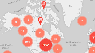
 |
| The Growth of Colleges in America |
Competition News
National Geographic Competition for College/Grad Cartographers
Undergraduate students and master's-degree candidates can apply for the
National Geographic Award in Mapping which recognizes student achievement in the art, science, and technology of mapping. Awards are $900 and $300 for first and second place and National Geographic products for honorable mentions.
The award is administered through the Association of American Geographers (AAG) Cartography Specialty Group (CSG). Static electronic submissions are judged by a panel of professional cartographers working at National Geographic and are due March 1.
- via Robert Roth at Wisconsin
Map Competitions at FOSS4G Events to Support International Map Year
Four events will have competitions. Details are still being worked out. I want to suggest the geospatial community needs to think of other activities besides competitions to recognize these events.
Map of Growth of Colleges in the U.S.
Glenn Letham at
GIS User shares an "
Impressive Map Effort [that] Showcases the Growth of Colleges in America." The map (above) is from "ecollegefinder.org" one of many sites offering to help students find "the right" school. Fuzzing up my eyes as a watch the animation I think I see a population growth map.
New GIS Education Resources
Jarlath O'Neil-Dunne of the UVM Spatial Analysis Lab offered a 44 minute VCGI
webinar on Unmanned Aerial Systems (UAS) or drones.
The term “drone” is often associated with a human-piloted, video-enabled system that is used for recreation, movie production, surveillance, or targeting. In this webinar we will take a look at a different class of drones, those are are developed solely for the purposes of creating accurate 2D and 3D mapping products using photogrammetric workflows. UAS workflow and output data products will be presented along with an assessment of the capabilities and limitations of these “mapping grade” drones.


