ABS Consulting Group, Inc.: Home | Blog | Resume | Speaking | Publications
Showing posts with label geoint. Show all posts

Thursday, May 16, 2019

GIS Education News: A Geospatial Intelligence Reading List


On and Off Campus

A small section of
Boulder's Child-Friendly City Map
Boulder Patch: Boulder Releases Kid-Friendly Map of the City - I noted this project a few weeks ago: "Two undergrads from the University of Colorado Boulder's Environmental Design Program designed the map using the input provided to them by organizations including Boulder Valley School District, the City of Boulder and other community organizations..." Now the map is online.

University of Kentucky: UK Geography 'Maps' its Way to a Better Lexington - Mapshop grew out of the New Mappings Collaboratory in the Department of Geography. It's an initiative that uses  "expertise in geospatial software and technical resources to assist the City of Lexington in raising critical mapping capacities."

Thursday, February 15, 2018

GIS Education Weekly: Northland and Brandman up their Geospatial Game

Resources

Jeff Howarth at Middlebury shared his reading list (image at right) for “Cartography and the City," a first year seminar. Via @forneycove.

Esri's John Nelson shared this story map about common geographic misconceptions noted by educators. It's based on a paper his father, a geography professor, wrote.

Wednesday, September 20, 2017

GIS Education Weekly: A Few Programs Change Plans

Programs

WPR: UW-Stevens Point Reorganizes Department Of Geography And Geology - The University of Wisconsin-Stevens Point is reorganizing its Department of Geography and Geology in response to budget cuts. The department will no longer exist as a stand-alone unit, but will be folded into other academic programs.

The University of Kentucky's New Maps Plus program is not currently accepting applications for its Master's program. I contacted the program via e-mail for comment, but have not heard back.

The Wade Edwards Learning Lab in Raleigh teaches young people GIS. "GAPS: The center's Geospatial Mapping program begins in a month. The eight-week program will take place on Saturday mornings for students in grades eight to ten who are interested in STEM."

Thursday, June 15, 2017

GIS Education Weekly: Students Map Chinatown Sounds, Abortion Clinics and Class Gifts

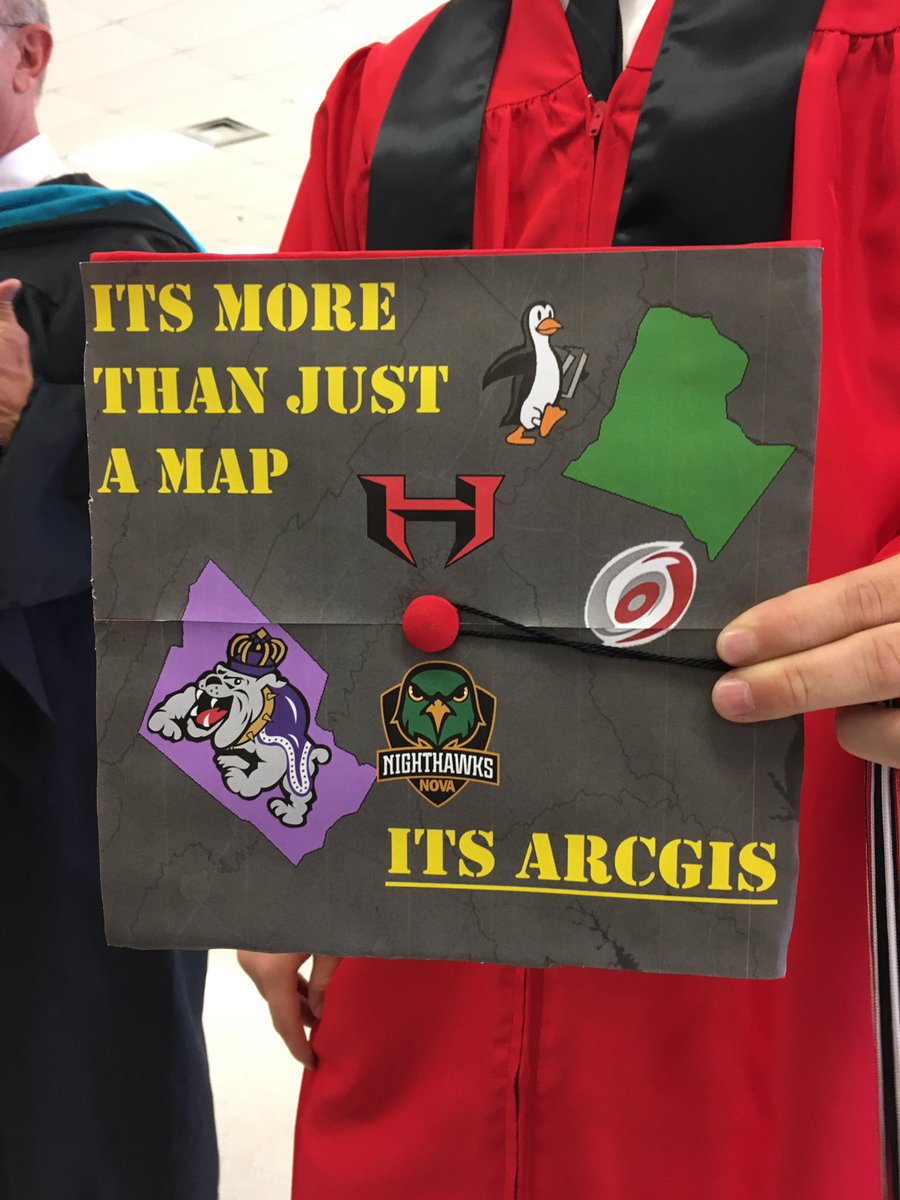
Cap Map
Resources and Articles

The Harvard Map Collection offers a story map of its current exhibition, Manuscript Maps.

At right is a graduation cap tweeted from Loudoun County (VA) Public Schools Geospatial Science program (@LCPS_GIS). The student in question included two counties on the mortar board: Loudoun (left) and Rockingham (right, home to James Madison and Geospatial Semester). I'd be ok with the lower text being "It's GIS."

Consumer Reports: Car Insurance Companies Charge Higher Rates in Some Minority Neighborhoods - An April 2017 report from ProPublica asserts: "First-of-its-kind data analysis finds price differences that can't be explained by risk alone."

Thursday, February 25, 2016

GIS Education Weekly: Space Archaeology Meets Crowdsourcing; 2016 Geospatial Skills Competition Meets Open Source

Space Archaeology for Everyone!

Parcak's book
Satellite Remote
Sensing for Archaeology
I noted Sarah Parcak last fall when she was awarded the 2016 TED Prize of $1M. This past week at the TED conference, she explained what she'll be doing with the funds. She'll be building a platform to allow anyone with a smart phone to look at processed satellite images to identify archaeological features. This will be another opportunity to help the world understand the value of remote sensing.

Moodle Supports Location-based Learning

Moodle is an open source learning management system. I was surprised to learn it has "conditional display based on location," what is called the Moodle GPS Course Format. A Moodle News article from 2014 on the plugin from the German company ka:media describes some applications:
Imagine the ability to hide materials until a student was in proximity to a specific place! Scavenger hunts, virtual tours of cities, geocaching challenges…I can think of a couple of cool ways to use this GPS format. With a responsive or Mobile theme this could be a really awesome and amazing way to bring interactivity to your blended classroom.
We can already do those things with existing LBS services, tools and APIs, but this implementation integrates them into learning via an LMS. If I understand correctly, the "Format," first announced in 2013, comes as part of a free set of tools and services from ka:media and as a download from Moodle.org. A version updated for Moodle 3.0 is expected in March. I could not find any documentation of implementations; if you know of any, I'd love to hear about them.

Subscribe!

Get your weekly GIS education update free, via e-mail, every Thursday.

Thursday, June 25, 2015

GIS Education Weekly: High Schoolers and Interns Solve Challenges, MOOCs, Essential Body of Knowledge

Bronx High School of Science Students find Use Cases for DigitalGlobe Imagery
Image by Ryan Jay Crisostomo CC BY-SA 3.0
This year at State of the Map [the OpenStreetMap US event], developers and users gathered at the United Nations in New York City to exchange information on the latest geospatial applications. Among the participants were 15 entrepreneurial-minded students from the Bronx High School of Science. The students were on hand to discuss their use cases detailing the application of satellite imagery, big data, and maps to solve problems challenging the commercial sector, particularly, real estate investment, infrastructure, and security.
Ninety students at the school were part of DigitalGlobe's Bright Ideas competition held at the top notch school. (I was in an NSF high school program one summer and the Bronx High School of Science students kicked my butt.) The good news:
The original ideas within these use cases are the intellectual property of these superb intellectual athletes, and their next step is to apply to for grants through the DigitalGlobe Foundation to further their ideas towards commercialization.
If the ideas come to fruition, DigitalGlobe will sell imagery. Is it possible this detailed imagery is still a solution in search of a problem?

USGIF Publishes GEOINT Essential Body of Knowledge

USGIF produced the GEOINT Essential Body of Knowledge (EBK, PDF). It conducting a cross-industry job analysis to identify the knowledge, skills, and abilities critical to the GEOINT positions. The document was developed in support of the upcoming Universal GEOINT Certification I discussed last week.

Subscribe!

If you'd rather get these weekly posts via e-mail, sign up here! That is all.

Tuesday, August 14, 2012

NGA Provides GEOINT Edu Grant to Historically Black College

Early in August Fayetteville State University (FSU) received a five-year $443,000 research grant from the National Geospatial-Intelligence Agency (NGA) to develop a Geospatial Intelligence (GEOINT) certificate to be offered to students pursuing undergraduate degrees in geography, computer science, and intelligence studies (press release). The four recipients of the grant are part of the university's Center for Defense and Homeland Security (CDHS).

I didn't realize FSU was a historically black college or university (HBCU) until another educator pointed it out. The certificate will be the first of its kind at an HBCU and FSU intends for its work to become a template for other schools interested in pursuing such offerings (press release).

The two year grant with three one year add-ons has several goals:
  • develop courses for the GEOINT certificate 
  • establish a geospatial teaching laboratory 
  • obtain certificate accredited from the United States Geospatial Intelligence Foundation (USGIF) 
  • develop an online component for the program 
  • expand the certificate to include allied programs such as Political Science
Currently, the university offers a B.A. and a minor in Geography and has three faculty members in the department. That said, the list of geography courses (which fall under History and Government) is quite long. I count four that deal with computer cartography and GIS. There's one remote sensing, course, too.

FSU, I have learned, is the second-oldest public institution in North Carolina., part of the University of North Carolina System. It serves about 6,000 students and offers 60 undergraduate and graduate degrees. Trajectory Magazine (from the USGIF) reports that the GEOINT program lead, Dr. Rakesh Malhotra, is a member of the USGIF Academic Advisory Board. Several other members of that board are involved in GEOINT programs at other universities.

The NGA includes HBCU grants among its academic research program, but does not cite this grant anywhere on its website, at least not yet.

Jeremy Crampton, at his Open Geography blog asks a number of questions about grants in general in the context of this announcement:
Would you take $443,000 from the government to build a Certificate Program? What about from a government intelligence agency?
This grant and the program it creates support a number of firsts for HBCUs, geospatial, NGA, USGIF, GEOINT and geo education. Many eyes will be watching its progress.