Esri Education GIS Conference
I'm involved with two sessions at the event, which starts Saturday, that might be of interest.
On Saturday at 8:30 am (first session of the conference), I'm hosting a workshop exploring how to leverage Esri's MOOCs within existing courses and programs. (Disclosure for new readers: I manage Esri's MOOC program.)
On Tuesday I'm hosting the education conference's "self organized sessions," basically a mini-unconference. This is a chance for attendees to set the agenda and cooperatively explore topics of interest. One topic is already on the agenda: GIS Course Improvement. Want to get warmed up? Here's a post I wrote after my first education "unconference."
Showing posts with label esrieduc. Show all posts
Thursday, July 6, 2017
Thursday, June 29, 2017
GIS Education Weekly: Google Earth, ArcGIS Pro and Coloring in the Curriculum
Resources and Articles
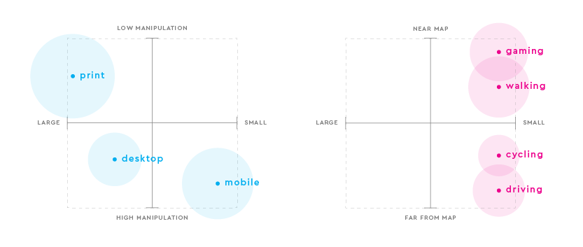
Mapbox Blog: Designing maps for mobile devices - Nathaniel Slaughter explores how to think about map scale, map size and the user's motion to make fit for purpose visualizations. As Bill Morris (@vtcraghead) pointed out on Twitter, the graphic at right is a keeper.
Integrating ArcGIS Pro & Web Mapping in the Cartography Curriculum
Monica Lloyd of Centre of Geographic Sciences (COGS, NS, Canada) offers a story map on the topic.
Mapbox Blog: Designing maps for mobile devices - Nathaniel Slaughter explores how to think about map scale, map size and the user's motion to make fit for purpose visualizations. As Bill Morris (@vtcraghead) pointed out on Twitter, the graphic at right is a keeper.
![]() |
| Map Size and Interactivity Levels |
Monica Lloyd of Centre of Geographic Sciences (COGS, NS, Canada) offers a story map on the topic.
Thursday, June 30, 2016
GIS Education Weekly: Esri Education GIS Conference
Esri Education GIS Conference
(Reminder and disclaimer: I have accepted a job with Esri. I was not in San Diego this past week and gathered this coverage from afar.)
Did you notice the map on the cover of this year's map book? It's Pat Kennelly's sky model terrain map! Kennelly teaches at LIU Post and Penn State. h/t @colorbrewer
The details of Esri making all e-learning free to all users (with qualifying products on maintenance) were shared at the opening Esri UC plenary. The new training site is not yet available, but a teaser site with a Q & A and video is. When launched the site will include education resources, including GeoInquiries and SpatiaLABS. Among the licenses and programs that qualify for the free resources are those commonly used in teaching and learning including Esri Higher Education Enterprise Licenses (Education Site License) and the ArcGIS for Personal Use Program.
(Reminder and disclaimer: I have accepted a job with Esri. I was not in San Diego this past week and gathered this coverage from afar.)
Did you notice the map on the cover of this year's map book? It's Pat Kennelly's sky model terrain map! Kennelly teaches at LIU Post and Penn State. h/t @colorbrewer
The details of Esri making all e-learning free to all users (with qualifying products on maintenance) were shared at the opening Esri UC plenary. The new training site is not yet available, but a teaser site with a Q & A and video is. When launched the site will include education resources, including GeoInquiries and SpatiaLABS. Among the licenses and programs that qualify for the free resources are those commonly used in teaching and learning including Esri Higher Education Enterprise Licenses (Education Site License) and the ArcGIS for Personal Use Program.
Wednesday, November 25, 2015
GIS Education Weekly: GeoBadges, US UAS Teaching, UW Maptime and Rhodes Scholar
GeoBadges
On November 16, among other things, MapStory announced the launch of GeoBadges on its blog.
DelawareView
Subscribe!
Don't miss any GIS education news. Subscribe to receive this newsletter via e-mail every Thursday - well expect today since it was delivered on Wednesday due to the Thursday Thanksgiving holiday in the United States tomorrow.
On November 16, among other things, MapStory announced the launch of GeoBadges on its blog.
This is also the week we launch GeoBadges.org out into the wild. GeoBadges is a digital badging platform that helps drive informal learning and community service within the broad field of geography. MapStory kickstarted GeoBadges with a grant from the Longview Foundation, and has since handed over stewardship of the project going forward to the American Geographical Society. In honor of OSMGeoWeek we’ve teamed up with TeachOSM to offer the first two OpenStreetMap badges targeted at new mappers and mapathon event organizers. Check it out!I recognized all the issuing organizations save GeoPlunge (@GeoPlunge). Best I can tell it's a card game that helps students learn geography facts which has been popular in DC for some years. I was surprised to find badges from OGC for participating in a OGC Technical Committee Meeting.
DelawareView
Faculty members in the University of Delaware’s Department of Geography have launched the DelawareView (DEView) consortium to improve public access to remote sensing and geospatial data.
DEView is an affiliate member of AmericaView, a national network of remote sensing scientists and GIS scientists, funded by the U.S. Geological Survey, who support the use of Landsat and other public domain remotely sensed satellite data for research, education and technology transfer.The university paper covered it on GIS Day.
Subscribe!
Don't miss any GIS education news. Subscribe to receive this newsletter via e-mail every Thursday - well expect today since it was delivered on Wednesday due to the Thursday Thanksgiving holiday in the United States tomorrow.
Thursday, July 23, 2015
GIS Education Weekly: Esri Education GIS Conference
Esri Education GIS Conference
For the first time in many years I did not attend the Esri Education GIS (EdUC) or Esri International User Conference (EsriUC). I read that more than 700 people attended EdUC and some 16,000 attended EsriUC. Below are the highlights of both events related to GIS education.
GeoMentoring
Both EdUC and EsriUC served as recruiting events for the Esri-AAG GeoMentors program. The goal is to encourage GIS users to reach out to formal and informal educators to help integrate the technology (ArcGIS Online) into their lessons and activities. Similar kinds of recruiting date back to the 1990s with Esri's Adopt-A-School program. I recall having my badge scanned by a National Geographic person at a 2009's EsriUC for the original GeoMentor effort.
Several GeoMentors were honored. @EsriEdUC shared a picture of
Dunny Green receiving the 1st Esri-AAG GeoMentor certificate!Green performed his GeoMentoring while aboard a U.S. Navy ship! Forrest Lamb was called out as a GIS Hero, and per Jack Dangermond "The best GeoMentor I've ever known."
AAG GeoMentors (@AAGGeoMentors) confirmed 60 new GeoMentor sign ups as of Wednesday night.
Building Apps and Coding
It's valuable to understand the kinds of apps Esri imagines (field, office and public) and three options for building these apps. Per Tom Baker (@trbaker) the creation tools to build them include:
templates, web app builder, App Studio (for native apps).App Studio seemed to be hit with educators. Per Shannon White (@shannonwhite):
2 minutes, a web browser and it’s an app.That said, Addy Pope (@GIS4HE) who heads education for Esri UK, shared this important bit:
And the message is...... GIS students should learn Python. But they are scared to pick programming optionSubscribe!
If you'd like to receive GIS education news weekly via e-mail, sign up here! And, please share these with others involved in teaching and learning GIS! Thanks!
Labels:
esrieduc,
geomentors,
weekly
Thursday, July 16, 2015
GIS Education Weekly: Commercial Products from USD and TAMU, Drone Classes, SAG Winners
Bringing Location-Based Learning to Life
![]() |
| WISE's User Interface |
Anonymous Funder Backs Drone Education in Detroit
Base 11, a non-profit from California, is planning to invest up to $1 million from an anonymous donor to bring a drone school and makerspace to Coleman A. Young International Airport in Detroit. There, students and the public can learn about the technology.
Base 11's for-profit subsidy will run an unmanned aerial systems (UAS) business from the facility at the airport. The effort has a few goals: to help Davis Aerospace Technical High School, which lost its accreditation get back on its feet and, in time, the development of a dual enrollment option with a local college.
Subscribe!
If you'd rather get these weekly posts via e-mail, sign up here! And, please share these with others involved in teaching and learning GIS! Thanks!
Labels:
commercial products,
esrieduc,
taumu,
weekly
Thursday, July 26, 2012
Esri Ed UC: PowerPoint Rules!
I saw a lot PowerPoint at the Esri Education User Conference (Ed UC) held this past week in San Diego. It was at the heart of nearly every session, save perhaps the one-on-one interviews in the two plenaries on Saturday and Sunday. And, to be fair, presenters were pretty much required to use PowerPoint (or at least were asked to submit one).
One comment struck me as I sat through yet another valuable but rather un-engaging session on Tuesday. The presenter shared that he was using the same slides he used in class.
That got me thinking. Do these educators teach the same way in school that they present at Ed UC? I can’t believe that’s the case for educators who spoke about inquiry, problem or project based learning. But I fear some use the same “sage on the stage” PowerPoint lecture format I spent ten or 15 hours watching this past week with their students.
That leads me to envision the conference I wish I could attend. I want to see presenters (specifically those who don’t use PowerPoint) teach. I don’t want them to tell me about how they teach, I want them to teach me and other attendees the same way they do in the classroom or online or informally.
Off the top of my head I thought of three sessions where active learning might have been especially effective.
- I wonder if Megan Patent-Nygren could have squeezed even a mini-version of her inquiry-based learning (one of the most memorable presentations I saw) into an actual activity we the attendees could do. She told us about it, but I wanted to “do it.”
- I wonder if Eileen Johnson, who spoke about using model builder in her project based learning courses, could have had us try just a bit of what her students do. Maybe she could have asked small groups to develop a way to explain the complex models to non-GIS stakeholders.
- I wonder if Tom Baker, could have use a different tactic than a big group discussion about possible ways Esri could help those involved in geographic education research at the research SIG meeting. Perhaps small groups could have developed and vetted ideas, sharing just their favorite with the whole group.
Why are we not modeling the move to active, participatory, group, problem, project and inquiry based learning going on in classrooms across the world at our conference?
I did try to execute this once at NEARC Educator’s Day. It didn’t work out very well in part because 20 minutes is not enough time to do even part of lesson. I want to suggest one way we might attempt this sort of session at EdUC or other events like the NEARC Ed Day. Organizers could set aside a few of the 75 minutes sessions and invite master teachers to teach their favorite or their most innovative GIS or geography lessons. Some might need a computer lab, but others might not. Would you want to attend those sessions? I would!
Every educator with whom I’ve shared this idea responded, “I’d attend!” Why? I can answer for myself only. The last time I saw another instructor teach (outside of a conference GIS lab session or a formal training class) was in 1988, the year I completed my Masters at Penn State. I’ll be honest, I need some new material! To be clear, I don’t need new things to teach, I need to steal new techniques, approaches, etc. And, I want to steal them from the best educators in the geography/GIS space.
Labels:
active learning,
conferences,
engagement,
esrieduc,
powerpoint
Subscribe to:
Posts (Atom)