Mapbox Blog: Designing maps for mobile devices - Nathaniel Slaughter explores how to think about map scale, map size and the user's motion to make fit for purpose visualizations. As Bill Morris (@vtcraghead) pointed out on Twitter, the graphic at right is a keeper.
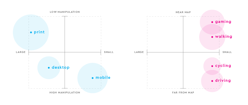 |
| Map Size and Interactivity Levels |
Monica Lloyd of Centre of Geographic Sciences (COGS, NS, Canada) offers a story map on the topic.
ArcGIS Blog: Contribute Your Campus Data to Esri’s Community Program! - Shane Matthews shares examples of campus maps and offers resources to add them to the Living Atlas.
TechCrunch: Google Earth comes to the classroom with new educational tours and lesson plans - Google puts Google Earth into Google Classroom and adds more tours.
Fleming College (Ontario, Canada): GIS students gain real world experience through collaborative projects - The college held a showcase to show off student work on real world projects. Several students already have jobs lined up.
Directions Magazine: GeoTech Shares Industry Insights, Resources at GeoEd ‘17 - Barbaree Ash Duke recaps highlights from the event.
GeoTech Center: Summer 2017 Newsletter (pdf) - The latest on the center's NSF grant, programs and more. Also available via Issu (registration required).
Esri: 2017 Esri Education Q&As - Everything you need to know about Esri's education efforts. The "kitchen sink" User Conference Q&A, from whence it came, is also available.
Digiday: How Atlantic Media’s CityLab plans to make niche work - How the now separate media business unit will make a go of profitability via (1) subscriptions/memberships and (2) native advertising. Re the latter: "So far, it’s done native ads for Mastercard, Esri and Living Cities."
Digiday: How Atlantic Media’s CityLab plans to make niche work - How the now separate media business unit will make a go of profitability via (1) subscriptions/memberships and (2) native advertising. Re the latter: "So far, it’s done native ads for Mastercard, Esri and Living Cities."
Directions Magazine: Need Data? Successful Geospatial Data Searching Strategies - This is not a list of where to search, but how to think about search. Joseph Kerski includes a few hands-on exercises.
Bird's Eye View GIS Blog: Teaching QGIS is a Labor of Love - Kurt Menke details about trying to make money as a teacher of open source GIS in today's world.
Education News
I keep an eye on Montessori schools. I did not attend one, but am friends with two families with kids who did, or do. There's a Montessori "spin off" Wildflower, that attempts to update the original vision with even more personalization. These schools operate "as one-room schoolhouses, led solely by teachers, that aim to make personalization a definition rather than a description of education. Each location supports three grade levels..." It turns out, there's one down the street from me in Cambridge, MA. I found this interesting:
I noted Achieving the Dream last year. It's a project to use open educational resources to build degree programs at community colleges. At one point, a team thought about a proposal related to GIS materials, but that didn't materialize. This week I learned there's news from the efforts so far: “A study on early returns, which was conducted by SRI International and the rpk GROUP, found that faculty members are changing their teaching in the OER courses and that students are at least as engaged in the courses as they are in conventional ones.” Via Inside Higher Ed.
A study from Duke suggests MOOCs can have a big impact on affective (emotional) learning.
I mentioned the Geospatial Data Act earlier this month, including its endorsement by the National Association of State Chief Information Officers, the National Association of Counties, the National States Geographic Information Council, and MAAPS.
This week, an organization not on that list, the American Association of Geographers, responds in a PDF on Dropbox. (Why is this document not on the organization's website?) "A bill recently introduced in the U.S. Senate could effectively exclude everyone but licensed architects, engineers, and surveyors from federal government contracts for GIS and mapping services of all kinds — not just those services traditionally provided by surveyors."
The last time this discussion came up, in 2007, there was a lawsuit (from MAPPS that was eventually dismissed due to lack of standing) and a new organization (Coalition of Geospatial Organizations, COGO) was launched to try to get the geospatial professional organizations on the same page.
Some further reading on the matter:
Bird's Eye View GIS Blog: Teaching QGIS is a Labor of Love - Kurt Menke details about trying to make money as a teacher of open source GIS in today's world.
Education News
I keep an eye on Montessori schools. I did not attend one, but am friends with two families with kids who did, or do. There's a Montessori "spin off" Wildflower, that attempts to update the original vision with even more personalization. These schools operate "as one-room schoolhouses, led solely by teachers, that aim to make personalization a definition rather than a description of education. Each location supports three grade levels..." It turns out, there's one down the street from me in Cambridge, MA. I found this interesting:
One development, created in conjunction with the MIT Media Lab, is trackers that are placed in different classroom learning areas, on teachers, and inside the slippers that students wear during class. The trackers map which activities the children use each day and how long the teachers spend with certain kids, allowing the educators to adjust their instruction.Competency-based programs were hot a few years ago. I for one haven't kept up, but read this week that the organization for colleges pursuing that vision is looking for new members. "The Competency-Based Education Network is a group of colleges and universities working together to address shared challenges to designing, developing and scaling competency-based degree programs." There's a list of current members here - including for-profits and community colleges; a few have GIS programs.
I noted Achieving the Dream last year. It's a project to use open educational resources to build degree programs at community colleges. At one point, a team thought about a proposal related to GIS materials, but that didn't materialize. This week I learned there's news from the efforts so far: “A study on early returns, which was conducted by SRI International and the rpk GROUP, found that faculty members are changing their teaching in the OER courses and that students are at least as engaged in the courses as they are in conventional ones.” Via Inside Higher Ed.
A study from Duke suggests MOOCs can have a big impact on affective (emotional) learning.
MOOCs can generate affective learning through four pathways or mechanisms:Government GIS News
- Sharing instructor enthusiasm
- Engaging with controversial topics
- Exposure to diversity
- Experiencing innovative teaching approaches
I mentioned the Geospatial Data Act earlier this month, including its endorsement by the National Association of State Chief Information Officers, the National Association of Counties, the National States Geographic Information Council, and MAAPS.
This week, an organization not on that list, the American Association of Geographers, responds in a PDF on Dropbox. (Why is this document not on the organization's website?) "A bill recently introduced in the U.S. Senate could effectively exclude everyone but licensed architects, engineers, and surveyors from federal government contracts for GIS and mapping services of all kinds — not just those services traditionally provided by surveyors."
The last time this discussion came up, in 2007, there was a lawsuit (from MAPPS that was eventually dismissed due to lack of standing) and a new organization (Coalition of Geospatial Organizations, COGO) was launched to try to get the geospatial professional organizations on the same page.
Some further reading on the matter:
- NSGIC (Cy Smith): Geospatial Data Act Sets Table for Performance and Accountability
- Bill Dollins: Thoughts on the Geospatial Data Act of 2017
- Reddit/GIS: Comments
GIS News
Mapbox announced a new tool this week. It takes colors from a photo you upload and uses them to symbolize a map. That's fun! The name for the tool, Cartogram, is not fun. I'm with Ken Field on this one.
Manifold released a free viewer: Manifold Viewer.
The Geography and Spatial Sciences (GSS) Program of the National Science Foundation (NSF) announced the release of a new GSS strategic plan as well as new program solicitations for both its regular and its doctoral dissertation research improvement (DDRI) competitions. Via AAG.
The National Center for Research in Geography Education (NCRGE), a research consortium headquartered at the American Association of Geographers (AAG) and Texas State University, has approved awards for three new projects under its Transformative Research grant program.
Honors and Awards
Monty Python alum Michael Palin was made a doctor of science by the University of St Andrews in recognition of his contribution to the subject of geography.
A project about air quality from the University of Oregon, The Kenton Lead Blob* created using an ArcGIS Story Map, won a national student Edward R Murrow Award for Excellence in Video Reporting.
In and out of the Classroom
In Juneau (AK) City Hall hangs a map made by second-graders. "Each kid worked on a grid, coloring in blue for water and green for land, and they patterned in symbols for traditional Tlingit uses of the land – hunting, berry picking, fishing." The project taught about mapping, Tlingit history and patterning. Also noteworthy: the teacher and perhaps the students learned the city has a cartographer, Quinn Tracy. He produced the map grids used to create the map.
For Students
@AAG_undergrads reminds undergrads "Nominations Sought for Inaugural Board of the AAG USAG." Nominations are due June 30, aka Friday.
Mapbox announced a new tool this week. It takes colors from a photo you upload and uses them to symbolize a map. That's fun! The name for the tool, Cartogram, is not fun. I'm with Ken Field on this one.
Manifold released a free viewer: Manifold Viewer.
Viewer is not a limited duration trial, Viewer contains no advertising and Viewer does not nag you to buy anything. Viewer is a massively functional, standalone product that can view data from thousands of different sources and perform powerful analysis. Viewer includes the most sophisticated spatial SQL in existence with hundreds of functions and hundreds of point-and-click transforms.Geography Funding News
For links to downloads see the Viewer page at http://www.manifold.net/viewer.shtml
The Geography and Spatial Sciences (GSS) Program of the National Science Foundation (NSF) announced the release of a new GSS strategic plan as well as new program solicitations for both its regular and its doctoral dissertation research improvement (DDRI) competitions. Via AAG.
The National Center for Research in Geography Education (NCRGE), a research consortium headquartered at the American Association of Geographers (AAG) and Texas State University, has approved awards for three new projects under its Transformative Research grant program.
Honors and Awards
Monty Python alum Michael Palin was made a doctor of science by the University of St Andrews in recognition of his contribution to the subject of geography.
A project about air quality from the University of Oregon, The Kenton Lead Blob* created using an ArcGIS Story Map, won a national student Edward R Murrow Award for Excellence in Video Reporting.
In and out of the Classroom
In Juneau (AK) City Hall hangs a map made by second-graders. "Each kid worked on a grid, coloring in blue for water and green for land, and they patterned in symbols for traditional Tlingit uses of the land – hunting, berry picking, fishing." The project taught about mapping, Tlingit history and patterning. Also noteworthy: the teacher and perhaps the students learned the city has a cartographer, Quinn Tracy. He produced the map grids used to create the map.
For Students
@AAG_undergrads reminds undergrads "Nominations Sought for Inaugural Board of the AAG USAG." Nominations are due June 30, aka Friday.