 |
| Part of the U.S. Geological Survey’s Unified Geologic Map of the Moon |
Washington Post (Kids Post): A new map shows the moon as it’s never been seen - The Unified Geologic Map of the Moon is a topographical map the USGS calls the “definitive blueprint of the moon’s surface geology.”
The New York Times: Can You Guess the Country? A Geography Photo Quiz for Students - A quiz.
UCGIS: Several of the presentations from this week's 2020 UCGIS Symposium are available on YouTube.
People
Bham Now: How to fit an MBA between tornadoes, an Alabama Power job - This is another sponsored post about a University of Northern Alabama graduate in GIS. If you found this article, would you have known is was sponsored? What about this one? Is it earned or paid?
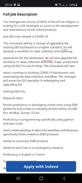
Kristin Warry called out @WHO regarding the job posting below, highlight the preference for a "he." The job posting was later removed. What's the best way to address things? Call organizations out on social media or send them a respectful private communication? Via @Kristinstweets reshared via @womeningis.
Contests and Challenges
Esri (GeoNet): Fun with GIS 269: 2020 Competition Results - This year more students submitted maps to the ArcGIS Online Competition for US High Schools and Middle Schools than any previous year! You can see the results in this story map.
Open Seventeen Summer Challenge - The Open Seventeen (O17) Summer Challenge is a prize-backed fully online coaching program for projects with innovative and implementable projects that leverage crowdsourcing and open source solutions to tackle the 17 UN Sustainable Development Goals (SDGs). The focus for this summer is the Covid health crisis and the social, environmental and economic challenges that the world will face. High school through graduate students can participate alone or in teams. Application deadline: June 10, 2020. Online coaching provided July 6-31 (2hr/weekday for 4 weeks). Via @FrancoisGrey.
Geography and Sousa
I participated in this "play along" with the Marine Band last week. I play the clarinet.
Jason K. Fettig, Director of United States Marine Band, and our conductor for the event, explained the geography covered in the trio of Stars and Stripes. I've been playing Stars and Stripes since high school and this is the first time I heard about its geography! I found this text in some materials Fettig prepared for music educators.
Inside GNSS: NavtechGPS Hosting GNSS and GPS/INS Course in Washington, DC Area- Remote Option Available - I note this because it's face to face, with a remote option, geospatial training set for July. It appears the fees are the same. It'll be interesting to see what happens with these multi-day, multi-thousand dollar, courses.

Contests and Challenges
Esri (GeoNet): Fun with GIS 269: 2020 Competition Results - This year more students submitted maps to the ArcGIS Online Competition for US High Schools and Middle Schools than any previous year! You can see the results in this story map.
Open Seventeen Summer Challenge - The Open Seventeen (O17) Summer Challenge is a prize-backed fully online coaching program for projects with innovative and implementable projects that leverage crowdsourcing and open source solutions to tackle the 17 UN Sustainable Development Goals (SDGs). The focus for this summer is the Covid health crisis and the social, environmental and economic challenges that the world will face. High school through graduate students can participate alone or in teams. Application deadline: June 10, 2020. Online coaching provided July 6-31 (2hr/weekday for 4 weeks). Via @FrancoisGrey.
Geography and Sousa
I participated in this "play along" with the Marine Band last week. I play the clarinet.
Jason K. Fettig, Director of United States Marine Band, and our conductor for the event, explained the geography covered in the trio of Stars and Stripes. I've been playing Stars and Stripes since high school and this is the first time I heard about its geography! I found this text in some materials Fettig prepared for music educators.
Sousa explained to the press that the three themes of the final trio were meant to typify the three sections of the United States. The broad melody, or main theme, represents the North. The South is represented by the famous piccolo obbligato, and the West by the bold countermelody of the trombones.Events
INTERGEO: The event is on - to be held both in person in Berlin and online October 13-15.
Programs and Courses
SLU: Saint Louis University Geospatial Institute Introduces New Programs - "Saint Louis University’s Geospatial Institute (GeoSLU) has introduced three new programs including a 12-month master’s program in geospatial science, a GeoHealth Certificate and a Geospatial Intelligence (GEOINT) Certificate." I could not find any further information, including if these are residential or online programs. Another source suggests it's a 9-12 month master's.
Building the Geospatial Center from The Ground Up - City University of New York - Sunil Bhaskaran discusses the program, funded by NSF-ATE & NASA-MISTC programs in an ArcGIS StoryMap.
News at UNG: IESA to offer new graduate certificate in geomatics - "The university's Lewis F. Rogers Institute for Environmental & Spatial Analysis (IESA) adds a new graduate certificate in geomatics in fall 2020.
St. Louis Business Journal: Why Maryville University’s business school is adding geotech to its curriculum - Sadly, the article is for subscribers only and there's nothing about it on the school website.
Coursera Blog: Helping college and university students regain control of their learning amid the pandemic with free access to Coursera - As of June 1 "college and university students around the world can learn and earn certificates on Coursera for free. Current undergraduate, graduate, or recently graduated students with a verified school email can sign up to get free access to over 3,800 courses, 150 Guided Projects, 400 Specializations, and 11 Professional Certificates. They can enroll in programs for free until July 31 — no credit card required. Once enrolled, they will have until Sept. 30, 2020, to complete the programs."
Practical Python Programming The course is available under Creative-Commons license. The author, David Beasley, writes: "Learn it, teach it, hack it, and have fun." Via @dabea.
University of California Agriculture and Natural Resources: UC Drone Camp is a four day online course June 22-25 with no flight practice sessions. Fees: $50 regular/$30 for academics (.edu address). Via @claremontGIS.
Clark State Community College: Summer Course in Geospatial Technology Puts Clark State Students “On the Map” - "Dr. Adam John Parrillo, associate professor and GIS/Geospatial program coordinator at Clark State. 'Geographic information systems is a technology born from human inquisitiveness and is a way to extend our own abilities to observe and analyze the world around us. While we examine the world, we can do this from safe distances using technology and data, so this program is able to be pursued online.'" The local paper's coverage makes the connection between GIS and virus tracking.
ASU Now (press release): 16 classes to explore this summer from ASU's The College - Among the 16 is "GIS 598 – Special Topic: GIS Methods for Non-Majors: Geographic Information Systems (GIS) are a valuable tool being used by professionals in a variety of industries. This four-credit, hands-on course is designed for students who are new to GIS and would like to learn how to use it as a tool and apply it to work in their particular field."

For Students
The informational interview is still a thing. I spoke with a graduating college senior last week who sadly, was not prepared for our meeting. If you or anyone you know is setting up one of these interviews, please review this post or one of the many others with information on how to prepare and how to follow up.
The Oracle (University of South Florida): COVID-19 Hub tracks coronavirus spread across Florida - USF Libraries received a grant of $25,000 from the Truist Financial Corporation to establish the COVID-19 Research and Information Fund. The fund was created to support programs geared toward research on COVID-19 including the COVID-19 Hub.
University of Missouri: The COVID-19 tracking tool from University of Missouri provides continuously updated 14-day snapshot of new cases of COVID-19 in every county in the nation. Via @karencapria.
On and Off Campus
The Tab: Newcastle Uni Geography students are donating strike compensation to food banks - The combination of a strike and the pandemic left these students in a particularly challenging situation. "Newcastle University’s Geography students have set up a drive to donate the 'insufficient' £100 they received as a refund for lost teaching to local food banks in the Newcastle area."
Evening Sun (West York, PA): West York school board allows climate change textbook to be added to curriculum - The text in question, "The Cultural Landscape: An Introduction to Human Geography, 13th Edition," by James M. Rubenstein, appears to be for AP Human Geography. The vote was 8-0 for approval.
ASU Now (press release): New ASU research empowers efforts to plan smarter, more resilient cities - "New research co-authored by Dylan Connor, assistant professor in the School of Geographical Sciences and Urban Planning, provides the most extensive picture to date of how urban development has unfolded in the U.S. over the past two centuries."
WWBT NBC12 News: Digital map provides access to historic African-American cemetery online - East End Cemetery, a historic African-American burial ground in Henrico is being mapped by the University of Richmond’s Digital Scholarship Lab, Department of Geography and the Environment, and Spatial Analysis Lab, students and volunteers organized by the Friends of East End. A beta version is expected in June with a full release in the fall.
Esri (Case Study): UC San Diego Makes GIS Accessible Across Campus - UCSD is using "enterprise login, SSO" to provide access to ArcGIS to users based on their university ID. Via @esriEd.
Esri (GeoNet): GIS for Everyone (...and how to build your own ArcGIS Dashboard to show it!) - Peter Knoop, an IT Admin for the University Of Michigan discusses how he used ArcGIS Dashboards, some custom Python scripts, and ArcGIS Notebooks to monitor ArcGIS Online organization usage. He shares templates and tips to help other organizations get started. Via Derek Law.Memorial University Gazette (Canada): Ideas and Technology -"The world’s first interactive mobile platform to connect global experts and small-scale fisheries communities is among four diverse projects benefitting from nearly $500,000 in federal funding." Three of the four grantees have a geospatial connection.
News from Adena