 |
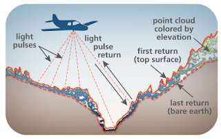
| Graphic from terrific story map that showcases the uses of lidar in Washington State |
Washington (State) Geological Survey: The Bare Earth How lidar in Washington State exposes geology and natural hazards - This story map shows how lidar is used to learn about events like landslides and tsunamis and features like faults and rivers.
Violent Metaphors: How to read and understand a scientific paper: a guide for non-scientists - Jennifer Raff helps us regular folks to get the most from, and not be misled, by scientific papers. Via
NY Times: What's going on in this graph? - A series from the Learning Network includes "Graphs, maps and charts from The Times -- and an invitation to students to discuss them live."
Esri Education Blog: Stop Teaching GIS - David DiBiase argues we should "teach how to learn GIS instead."
A @smithgis way to start a GIS class: Each student reads her fortune from a fortune cookie and adds "with GIS." Sample: "The great aim of education is not knowledge but action... with GIS." Nice!
Courses and Programs
UCLeXtend: Introduction to Citizen Science & Scientific Crowdsourcing - A free MOOC with some experienced CitSci academics. "This course aim is to introduce you to the theory and practice of citizen science and scientific crowdsourcing."
Events and Opportunities
The Esri Higher Education Open House is set for Friday March 9 from 10:00 am to 3:00 pm
TRELIS workshops are designed for women working in higher education in the geospatial sciences (GIS, remote sensing, cartography, and related mapping sciences). Sessions will focus on five themes: Career Trajectories & Leadership, Mentoring & Coaching, Communication & Language, Dealing with Obstacles, and Work-Life Balance, all in the context of the geospatial sciences. Travel, accommodations, food and registration are provided via NSF grant. The first workshop is in Madison, WI in May, and includes participation in the UCGIS Symposium that will take place immediately afterwards.
Youth Mappers offers 2018 Research Fellowship - It's a nine-month program for "a university faculty mentor together with one undergraduate or graduate student who is currently enrolled in any field at an institution of higher education that has a YouthMappers chapter in good standing." Recipients will get $8,000 for their project related to the use of open geospatial data for research on resilience of vulnerable populations around the world. Deadline Jan 15th.
PacktPub offers all ebooks and videos for $5 each. For how long? "Ends soon." Here's the GIS list.
Esri shared the Fall winners of its Teacher Video Challenge. There are more opportunities for the $500 prize for K-12 teachers.
In partnership with the U.S. Department of State's Virtual Student Federal Service Interns, the Next Generation Global Health Security Network is launching the 2018 Infectious Disease Mapping Challenge. The goal of the challenge for college and grad students is to promote mapping to address the objectives of the Global Health Security Agenda (GHSA), a global effort to create a world safe and secure of the threat of infectious disease. "Particularly noteworthy submissions will have the opportunity to brief officials on their findings."
On and Off Campus
The Inquirer: Two-plus hours on a school bus: How a Chester charter taps Philly kids to grow - "Information obtained by the Inquirer and Daily News shows the longest journey for Philadelphia students heading to Chester Community is on a kindergarten bus whose first scheduled pick up is at 5:24 a.m. at Academy and Newberry Roads in the Far Northeast. After 16 more stops, the bus delivers some children to Chester Community’s West Campus on Bethel Road in Chester Township at 8:05 and drops others off at the school’s new campus in Aston 10 minutes later." There's a map, too.
Greene County (VA) Record: Schools seeking healthier workers - And, they want GIS users to identify walking paths. "Pursel also wants to enlist students familiar with Geographic Information Systems to map out walking and running routes around school facilities. While the William Monroe High School track is open most of the time to the public, it can become boring to walk the same path day after day."
Greene County (VA) Record: Schools seeking healthier workers - And, they want GIS users to identify walking paths. "Pursel also wants to enlist students familiar with Geographic Information Systems to map out walking and running routes around school facilities. While the William Monroe High School track is open most of the time to the public, it can become boring to walk the same path day after day."
Industry News
Press release: Daimler announces investment in what3words - The company bought about a 10% share of What3Words. Further, "Mercedes-Benz will be the first automobile manufacturer to integrate the new 3 word address system and make it available to its customers."