
LinkedIn: Geospatial resources for schools - Thierry Gregorius shares a slide deck and other ideas for taking geospatial ideas into schools. I can download the PDF, but have not been successful at downloading the 30 Mb PPT file.
The Geography Teacher: 2020 Census Special Issue - Taylor and Francis made the issue open access until May 1. Via Linda Peters on LinkedIn.
Geospatial Historian - The website, which hosts geo lessons related to history, has more visitors each year. James Burnford asks on Twitter for help updating activities to QGIS 3 and ArcGIS Pro.
Vas3k Blog: Machine Learning for Everyone - Vasily Zubarev explains machine learning in a fun, if adult-focused way. Via LinkedIn.
Crunchy Data: The company offer several tutorials (no sign in or e-mail required) on PostGreSQL and PostGIS for administrators, DBAs, and developers. When I poked around I found a sandbox to play in! Via Glen Letham on LinkedIn.
Twitter: Tim Wallace of the New York Times explains the machine learning/big data effort to develop the map of changes in the U.S. landscape presented here.
Twitter: This thread is a discussion about whether the New York Times/Mapbox does or does not correctly attribute its use of OpenStreetMap.
Azavea Blog: How to Find the Most Recent Satellite Imagery Anywhere on Earth - "... every project starts with the same question: based on what you care about in the imagery, what’s the newest, cheapest, and highest-resolution imagery we can find?"
Twitter: Alberto Cairo announced that (most of) the graphics from his book How Charts Lie are freely available.
Esri HigherEd-L (registration required, see this post for details): Long and valuable thread about how to set up your GIS lab infrastructure including tables, chairs, projectors, etc. The question comes from Suzanne Wechsler at CSU Long Beach. I am aware of three professional GIS women from my tiny suburban Boston 300 person elementary school: Suzanne, Ann Hitchcock and me.
Esri HigherEd-L (registration required, see this post for details): Long and valuable thread about how to set up your GIS lab infrastructure including tables, chairs, projectors, etc. The question comes from Suzanne Wechsler at CSU Long Beach. I am aware of three professional GIS women from my tiny suburban Boston 300 person elementary school: Suzanne, Ann Hitchcock and me.
Australia Bush Fire Maps
Twitter: There are several threads regarding misleading maps of the bush fires in Australia. Here's one example.
BBC: Australia fires: Misleading maps and pictures go viral Via Ken Field.
Snopes: Australia Fires ISS Image. Via Rich Schultz.
ABC 23 TV: Scale of Australia's fires compared to map of United States - "In a Facebook post by the Sonoma County Fire District, a map of Australia's fires is juxtaposed with a map of the United States, revealing just how massive the inferno is."
EDUCAUSE: 2019 Study of Faculty and Information Technology - "A majority (51%) of faculty prefer to teach in a blended environment that includes both face-to-face and online components." Via Pat Kennelly on LinkedIn.
Hack Education: The 100 Worst Ed-Tech Debacles of the Decade - One of my favorite education writers, Audrey Watters, recaps the dark side of edtech between 2010 and today. If you want a map, see #41 The K-12 Cyber Incident Map.
VR Focus: Top 10 VR Education Apps Of 2019 - I see this list as a "state of the art" indicator. There are a number of simulations (think dissection), but also gamification and a few apps that cover history and geography.
New York Magazine: Survey: Most Americans Can’t Find Iran on a Map - "Just 23 percent of poll respondents were able to properly pick out Iran; When presented with a smaller map, showing just the Middle East, the number rose to 28 percent." The survey in question is discussed by its authors, Morning Consult, "a global technology company revolutionizing ways to collect, organize, and share survey research data to transform how decisions are made," here. More than one observer suggested there was trolling going on.
On and Off Campus
UW: Final Projects: Tim Prestby shares intro and advanced cartography projects from Rob Roth's fall 2019 courses. Via Twitter.
NBC: UNC campus police used geofencing tech to monitor antiracism protestors - "State investigators and college police used a controversial tracking technology called 'geofencing' to collect personal information from the cellphones of antiracism protestors at the University of North Carolina after being tipped off by the FBI, according to documents obtained by NBC News via a freedom of information request." The technology is from a Vermont-based company called Social Sentinel. Via @AudreyWatters.
WJHL: Erwin students using GPS technology to identify sidewalks in need of repair - "The Unicoi County [Tennessee] 4H GPS team, made up of students in grades 6 through 12, is mapping the conditions of Erwin’s sidewalks."
UNG: Geology professor creates 3D tactile map for students with Disabilities - Dr. Katayoun Mobasher, professor of geology in the Institute for Environmental and Spatial Analysis (IESA) at the University of North Georgia (UNG) developed both a tactile map and a tactile fossils.
CU Boulder: Map Librarians Connect Classes with Maps - "The number of classes held in the Map Library has been steadily increasing, due to the team spirit of Map Librarians Ilene Raynes and Naomi Heiser. "
Programs, Courses and Events
AAG: "Very cool project to create story maps of the careers of geography alumni! Great idea for departments to consider within their own geographic context." Dan Trudeau at McAlester College spearheaded the project. Via @theAAG.
MyBuckhannon: GSC to Offer Certificate in Geographic Information Systems - "The Glenville State College Department of Land Resources [WV] has introduced a new online certificate in geographic information system (GIS)" that will be available starting in Fall 2020.
LinkedIn: Andrew Cutts (who hosts a blog and podcast about imagery) now offers his posts arranged into a course on Geospatial Python including vector (GeoPandas) and raster (Earth Observation). Here's the blog post introducing it and here's the course itself on GitHub. Andrew is transparent: "This is not a bespoke Geospatial Python course, more a collection of blog posts combined into some order."
UMN: "This seven-hour workshop introduces participants to using a geographic information system (GIS) to analyze data and create maps."
Twitter: Adam Dastrup notes on Twitter: "I'll be doing a webinar about my Open Geography Education OER work on Jan 15. Sign up!" It's hosted by Directions Magazine and the GeoTech Center.
Esri: A free webinar aimed at students, professors and teaching staff in higher education in planning titled ArcGIS Urban for Design and Planning Courses will be January 23, 2020, from 9:00 a.m. to 10:00 a.m. (PST). Via Esri HigherEd-L.
Salisbury University: SU's Online Master's Program in GIS Management Again Ranked No. 1 in U.S. - The ranking is from Best College Reviews.org.
Quote of the Week
People
FHSU: FHSU Selects New Dean after National Search - "Fort Hays State University announced today the selection of Dr. Grady Dixon as the new dean of the Peter Werth College of Science, Technology and Mathematics." Dixon has a PhD in geography from Arizona State.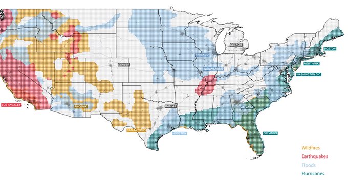
The maps in this @McHargCenter atlas are a disgrace. First job: projections. If you can't get that right, don't bother. Rest of the story is fundamentally compromised.- Ken Field on America After Climate Change, Mapped via Twitter.
People
South Philly Review: 'Geography Lady' Alycia Larson sharing world knowledge with kids - "Being known as 'The Geography Lady' suits the 38-year-old South Philly resident [lycia Larson] just fine as she continues to spread her wealth of worldly knowledge across the Philadelphia area."
Contests
Esri (GeoNet): 2020 Innovative Applications of Esri GIS Technology Poster Competition at AAG Annual Meeting - "In this [conference] session, you will learn from others as you discuss your poster with people from all over the world. Cash awards in 4 categories will be given, but even more importantly, this is an opportunity for your students and colleagues to showcase the innovative things they are doing with Esri GIS technology to help understand and solve the most pressing local-to-global problems of our time [UN Sustainable Development Goal (SDG)]." I see that Pix4D also has a poster contest at the AAG meeting.
DOE: 2020 U.S. DOE Geothermal Design Challenge – GIS Mapping – now open - "Student teams of two or three will use GIS mapping to create a compelling infographic/poster or interactive map to discover potential opportunities from this renewable energy source." Participants can use any software they like for their project.
Twitter: Aileen Buckley posted: "Ten students will receive $750 assistantships for #AutoCarto2020. Applications are now being accepted from post-secondary students at all levels both nationally and internationally. The deadline for applications is February 14." Details here.