 |
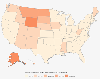
| Percent of population more than 60 minute drive from a college; |
Flowing Data: Most Common Jobs, By State - A nice set of "small multiples" to interpret. Via @John_M_Nelson.
ArcGIS Online: Lisa Berry's map shows the predominant level of education of the US population age 25+ by county and census tract centroids. The data are from the 2012-2016 American Community Survey 5-year estimates.
On and Off Campus
LinkedIn: NSF-ATE Geospatial Workshops for High School students - Promoting Spatial Thinking - Students from different New York City middle and high schools took part in a series of Geospatial Workshops hosted at the BCC Geospatial Center of the CUNY CREST Institute in July.
Staten Island Live: Youth in foster care attend special summer program at CSI "High school students in foster care from schools across New York City were given the opportunity to live and study at the College of Staten Island this summer." They lived on campus and took STEM courses including one on GIS. "Students also participated in a Geographic Information System (GIS) program taught by CSI's Urban Policy Analyst and GIS specialist, Nora Santiago. Students learned the GIS production process, including data-modeling, acquisition, editing, analysis and cartographic output." Two thoughts: (1) the more students who run into GIS in high school, the better and (2) the more high school students who spend time on campus learning how college works, the better.
The Gazette: Local middle-schooler wins statewide mapping contest - Laura Hubbs, 13, of Hiawatha IA won the state mapping award and moved on to the national competition. Her map included parks in the Hiawatha, Cedar Rapids and Robins.
Staten Island Live: Youth in foster care attend special summer program at CSI "High school students in foster care from schools across New York City were given the opportunity to live and study at the College of Staten Island this summer." They lived on campus and took STEM courses including one on GIS. "Students also participated in a Geographic Information System (GIS) program taught by CSI's Urban Policy Analyst and GIS specialist, Nora Santiago. Students learned the GIS production process, including data-modeling, acquisition, editing, analysis and cartographic output." Two thoughts: (1) the more students who run into GIS in high school, the better and (2) the more high school students who spend time on campus learning how college works, the better.
GIS Lounge: The Debate About Book Availability Via Esri’s Desk Copy Service - I'm not sure there's a debate; there's a disagreement between the publisher and an academic about which books should be provided to educators for free review. My quick and dirty research suggests publishers use the term Desk Copy differently than Esri.
For Students
AAG: The new edition of the AAG's Guide to Geography Programs in the Americas is available. It includes programs in North and South America, plus places of employment and 2016/17 theses and dissertations. Via @theAAG.
The State of Geospatial Media
A piece provided by USGIF titled "Geospatial Intelligence: The totally made-up term that’s changing the world" was posted as an op-ed, a post on LinkedIn, a blog post, an event, and a press release. In other news, a geospatial publication confused Manifold Technologies of Silicon Valley which works with the blockchain, with Manifold Software Limited, which develops GIS software, of Hong Kong.