I spent the day in the education track, which had between 10 and fifteen people for most of its four presentations (pdf of agenda). I wanted to share some of the presenters' and attendees' key ideas, as well as some of the thoughts that popped into my mind during the sessions.
Organizing Processes for Educators and Students
I now have a handout titled Many Ways to Bring Your Data into ArcGIS Online. (It and other docs are here.) It details 10 different ways to bring "internal" and "external" data into ArcGIS Online. This is how an educator thought to teach other educators about the various processes. I searched the Web a bit and could not find any other document arranged quite this way. Educators think about teaching/learning/organizing differently than others.
Reinventing the Wheel
 While we explored the different ways to bring in data, specifically downloading and publishing data from the Maine Office of GIS during the above workshop, one attendee spoke up. He asked in essence, why the state does not offer these data as feature services. He asked educators and GIS professionals to let the states (and I'll argue any other orgs) know the value of these services to educators and their students.
Professional vs. Educational Software
I was reminded as presenters and attendees got lost among menus and had error boxes pop up, that ArcGIS is not designed for education.It is designed for professionals/experts. This is a blessing and a curse for educators and students.
Money for Something
The folks at the New Hampshire Educational GIS Partnership are working hard to make their money go further. How? They offer the first stipend for an institute (a several day workshop) with no strings. But, to get the second one, you have to actually implement GIS in the classroom. Alas, only a small percentage take advantage of that second or later offering. I like the idea of the carrot.
Communities of Practice
Communities of Practice
I kept trying to bring up the concept of communities of practice/learning communities since I think that's a lot of what's missing in growing K-12 educators using GIS. I did see a slide of all the e-mail addresses for the folks behind the New Hampshire statewide Esri license. One to one can work but there's a special energy with a group. BTW, here's a link to that organization's ArcGIS Online home page; for other state focused education ArcGIS home pages, see this ThinkSpatial post.
I have yet to hear about active peer to peer K-12 GIS communities - whether they meet face to face or online. And, that's not for lack of trying. The NH Ed GIS Collaborative Ring, from the New Hampshire Educational GIS Partnership, exists. As occurs in many other online K-12 groups I follow, most posts are broadcasts from a single active individual (Hi Ina!).
When I asked if any of the attendees visited GeoNet I got a groan in response. I'll paraphrase what I thought was a valid description of GeoNet: They [Esri] took an ok set of forums and made them worse.
How do we build valuable communities of practice for K-12 educators?
Barriers to Entry
While everyone agreed that Esri providing ArcGIS Online to K-12 schools lowered one barrier to entry for introducing GIS in schools, there are others:
- Finding the time and place to introduce the technology
- Finding the hardware
- Setting up the Organization (NB: Choose the name of the organizations with care - forget mixed case and punctuation marks. Unlike a password, this should be easy to remember and type!)
- Finding support (via GeoMentors, communities of practice, or otherwise)
Make it Authentic and Share It
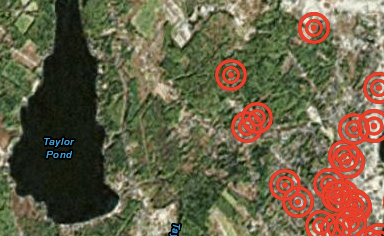 |
| Students plotted locations where they feel unsafe. |
Erin Towns is a poster child for jumping into GIS. Her site, which supports her high school global studies students among other courses, is a wealth of information.
She had her Auburn, ME students map where they felt unsafe in their city. Following FERPA (I think that's the first time I'd heard the acronym at a GIS ed conference, though I here it regularly from Audrey Watters), they used only their initials and detailed what was at the location and why it made them feel unsafe. She sent it off the chief of police without expecting much. The students were invited to present their findings to the community. Towns uses the phrase "giving the students a voice" quite often.
She had her Auburn, ME students map where they felt unsafe in their city. Following FERPA (I think that's the first time I'd heard the acronym at a GIS ed conference, though I here it regularly from Audrey Watters), they used only their initials and detailed what was at the location and why it made them feel unsafe. She sent it off the chief of police without expecting much. The students were invited to present their findings to the community. Towns uses the phrase "giving the students a voice" quite often.
It's all About Data Collection
In K-12 GIS education data collection is king. One whole session was devoted to exploring a favorite app, Track Kit, which everyone seemed to find powerful and easy to use. Another session favored MotionX GPS. None of the educators used Collector; only one person even explored Survey123.
Why we Go to these Events
At one point during a hands on session, attendees needed to zoom in. Someone popped up and noted that "zoom box" (aka press and hold the Shift key and drag a box on the map) works with most Esri products. This tip was met with great excitement!
Click all the Buttons
I especially loved the "no fear" and "just play" attitudes of the educators who presented and attended. How do you learn to use apps? Click all the buttons! How do you learn from interactive maps? Click all the buttons.